Muir Woods, Sausalito & Stinson Beach: One-Day Itinerary
If you have one day in Marin County and want more than a drive-by look at the redwoods, this is the loop that works. Old growth in the morning, Pacific beach at lunch, a Mount Tamalpais viewpoint, and a ferry back to San Francisco at sunset.
9:00 AM — Muir Woods
Leave San Francisco by 8:15 AM. The drive across the Golden Gate Bridge, up Highway 101, and over to Muir Woods Road takes 45 minutes without traffic, longer on weekends.
Book your Muir Woods parking reservation for a 9:00 or 9:30 AM arrival. Early slots are the quietest — tour buses typically do not arrive until 10:30 and the parking lots start to fill by noon.
Do the main trail loop to Cathedral Grove and back — about 1.5 miles round trip, 90 minutes at a relaxed pace. If you want more distance and fewer people, add the Hillside Trail on the return (adds a mile, adds elevation, mostly empty).
Plan ahead: See our trail guides and parking page. Reservations sell out days in advance on weekends.
11:30 AM — Drive to Stinson Beach
Leave Muir Woods, take Muir Woods Road back to Highway 1, and follow the coast north. The drive is 8 miles and takes 20 to 30 minutes — the road is narrow and winding and you will want to stop for ocean views. Do not rush it.
There are two worthwhile pullouts on the way: Muir Beach Overlook (WWII bunker, dramatic cliff views) and the Steep Ravine Trail access point (trail down to a rocky cove).
12:00 PM — Stinson Beach
Stinson Beach is a three-mile crescent of white sand. Park at the county lot (free) or the GGNRA lot at the south end. In summer and on sunny weekends, arrive early — the lot fills by 11 AM and cars queue back to the village.
For lunch, a few good options in the village:
- Parkside Cafe & Snack Bar — fish and chips, clam chowder, beach-side since 1949
- Sandpiper — bakery sandwiches and coffee for a picnic on the sand
- Siren Canteen — small-batch pizza, local beer (seasonal hours)
Budget 90 minutes for lunch and a beach walk. If the fog is in, eat indoors and keep moving — Stinson without sun is not worth a long stay.
2:00 PM — Mount Tamalpais Pantoll Area
From Stinson Beach, drive back south on Highway 1 and turn east on Panoramic Highway. In eight miles you reach Pantoll Ranger Station, at 1,500 feet elevation on the shoulder of Mount Tam. Parking is $8 per vehicle (self-pay).
From Pantoll, two short options:
- Old Mine Trail to the overlook — 1-mile round trip, gentle grade, ocean-and-Tam views
- Matt Davis Trail to Rock Spring — 2.5-mile round trip, a little more climbing, through oak woodland
Alternatively, drive five more miles up to East Peak (the actual summit, 2,571 feet) for panoramic 360° views of San Francisco, the East Bay, the Pacific, and on clear days the Sierra Nevada. Short flat trail around the summit.
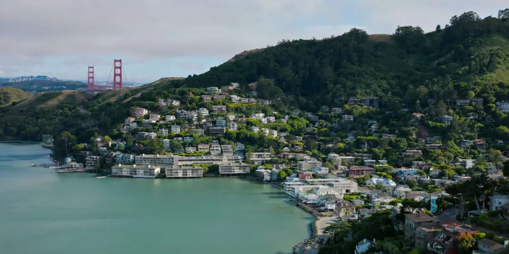
4:00 PM — Sausalito
Drive down Panoramic Highway, connect to Highway 1 and then Bridgeway into downtown Sausalito. About 20 minutes of driving. Park in one of the downtown pay lots (budget $20 to $25 for two hours) or hunt a metered street spot.
Walk Bridgeway waterfront — the view of San Francisco across the bay from Sausalito is one of the best in the Bay Area. Good stops:
- Plaza Vina del Mar — the main square, with fountains and the Bay Area’s most photographed palm trees
- Bay Model Visitor Center — Army Corps of Engineers working hydrodynamic model of San Francisco Bay (free admission)
- The Trident or Scoma’s — classic waterfront drink with a view
5:30 PM — Ferry Back to San Francisco
The Blue & Gold Fleet ferry runs from Sausalito’s main pier to Pier 41 at Fisherman’s Wharf. The last ferry is typically around 7:00 PM on weekdays and 7:45 PM on weekends — verify current schedule before you commit.
The ferry ride is 30 minutes of Golden Gate Bridge, Alcatraz, and city-skyline views. Sunset timing in summer is perfect for this. Ticket is about $14 one way.
If you drove, you can also take the ferry across with your car on the Golden Gate Ferry (different operator, Larkspur–San Francisco, not from Sausalito proper) — but most visitors leave the car in Sausalito pay lots and take the passenger ferry.
Practical Notes
Weather: Marin County microclimates are dramatic. Muir Woods is 10°F cooler than San Francisco, Stinson can be foggy even in summer, Mount Tam is often above the fog with a clear view. Layers are essential.
Food pacing: Plan lunch at Stinson. The Muir Woods cafe is fine but limited. Sausalito is expensive — if you are price-conscious, save your main meal for back in SF.
Driving: Highway 1 along this stretch is narrow, winding, and popular with cyclists. Do not attempt this itinerary if you are not comfortable with tight coastal driving. If you want to do the route without a car, a guided Muir Woods & Sausalito tour covers the park and Sausalito but skips Stinson and Mount Tam.
Doing this in reverse: You can flip the day and go Sausalito first, Muir Woods mid-day, Stinson in the afternoon. But Muir Woods is much better early — parking and crowds both degrade after 11 AM.